Environment and Climate Change Canada says there could be up to 20 centimetres of snow by Sunday morning. Check back here for live updates on snow conditions along B.C.’s South Coast all weekend.
Cold Arctic air is forecast to move in and mix with the Pacific along B.C.’s South Coast this weekend, which can only mean one thing: snow.
“Amounts are uncertain at this time but accumulating snow is likely in many areas this weekend,” according to a special weather statement issued by Environment and Climate Change Canada.
There’s a chance of rain or snowflurries on Saturday and Sunday, and then periods of snow forecast for Monday.
Residents are being asked to prepare accordingly, while various municipalities are readying their road clearing and snow removal equipment.
Some higher parts of the region could receive up to 30 centimetres of snow by Monday.
Read on for the latest B.C. snow updates. Check back often as we’ll be updating this page throughout the day.
Saturday, Feb. 1
Snowfall warning now in effect for Metro Vancouver
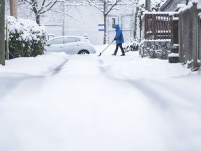
A snowfall warning was posted early Saturday for Metro Vancouver, with up to 20 centimetres expected Saturday night and Sunday morning.
Environment and Climate Change Canada says a wintry mix of weather conditions is expected to impact the South Coast of B.C. through Monday morning.
The federal weather agency says the highest amounts will likely occur over higher terrain, but other areas may see locally intense flurries.
Drivers are being warned that flurries could reduce visibility and there could be heavy snow accumulation on the roads.
Meteorologists say the precipitation will taper off to wet flurries or showers Sunday afternoon.
Another round of heavy snow may develop Sunday night into Monday morning.
The agency says visibility may be suddenly reduced at times in heavy snow. Surfaces such as highways, roads, walkways and parking lots may become difficult to navigate due to accumulating snow.
Alert posted for blast of Arctic air and blowing snow on B.C.’s South Coast
Environment and Climate Change Canada has posted a special weather statement for blowing snow and Arctic outflow conditions for Vancouver Island, the Southern Gulf Islands, the Sunshine Coast, Howe Sound, Whistler, Metro Vancouver, and the Fraser Valley.
The alert says a wintry mix of weather conditions is expected to impact B.C.’s South Coast over the next several days.
Heavy flurries and cold temperatures are expected this weekend as Arctic air blows over the region with precipitation.
The federal weather agency says next week will be very cold, as an Arctic ridge of high pressure settles over the region.
Temperatures will be 5 C to 8 C below seasonal. Blowing snow is possible through the Fraser Valley with recent snowfall.
The agency says strong outflow winds will result in cold wind chills.
Friday, Jan. 31
Between five and 30 centimetres of snow expected by Monday, says meteorologist
While it’s difficult to forecast precise accumulations of snow, a meteorologist with Environment and Climate Change Canada says Metro Vancouver and the Fraser Valley can expect between five and 30 centimetres of snow by Monday depending on elevation.
Lisa Erven said there will likely be intermittent snowflurries on Saturday, with some accumulation, but the significant snowfall is expected by Monday.
“Sunday night into Monday morning is the likeliest potential for heavy snowfall but the range of snowfall is quite drastic,” she said on Friday.
“It could be anywhere from five up to a localized 30 centimetres. But it’s going to be highly variable … It is critical that anybody who has weather-sensitive activities they check the forecast within a 24 hour period before doing those activities.”
Erven said on Saturday there could be “a quick trace to five centimetres with a risk of 10 centimetres” in Metro Vancouver, depending on elevation.
Arctic air is then forecast to swoop in, making temperatures drop between five and 10 degrees early next week, said Erven, adding Arctic outflow wind will likely whip across the Fraser Valley, Langley and White Rock.
Erven urged all residents of B.C.’s South Coast to prepare for “drastically varying conditions” between destinations on Sunday and Monday and to pack extra warm clothing, water and food in the car for emergencies.
All drivers are being asked to budget extra travel time from Sunday to Monday, and to drive slow.