Environment and Climate Change Canada has issued a snowfall warning for the Coquihalla Highway and the Okanagan Connector.
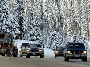
Metro Vancouver residents planning to head out early for their spring break road trip to the B.C. Interior and beyond should make sure they still have their snow tires.
Recommended Videos
It looks like some of B.C.’s highways will be snowy and slippery. Environment and Climate Change Canada issued snowfall warnings Thursday for the Coquihalla Highway and the Okanagan Connector, saying up to 15 centimetres of snow is possible.
The federal weather agency says a low-pressure system passing through southeastern British Columbia will bring snow to some mountain passes.
The Trans-Canada Highway between Eagle Pass and Rogers Pass is also under a snow warning where the snowfall is expected to intensify before the weather system moves away from the region later on Thursday.
The agency is warning that driving conditions may be hazardous.
Farther south, Environment Canada has issued a winter storm warning for Highway 3 from the Paulson Summit to Kootenay Pass.
It says that significant snowfall of up to 25 centimetres is expected along high elevations and flurries are expected until the low-pressure system tracks away from the region Thursday evening.
As for Metro Vancouver, temperatures are expected to dip down to 3 C overnight Thursday but it doesn’t look like there’s any snow in the forecast.
Expect a rainy start to spring break as well, with periods of rain or showers on Saturday and Sunday with daytime highs of 8 C and 9 C, respectively. More showers are in the forecast for Monday and then Tuesday looks a bit brighter with a mix of sun and cloud before it’s back to rain on Wednesday.
With files from The Canadian Press