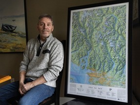
Jeff Clark’s last map was of the Salish Sea, and won an international award.

Map-maker Jeff Clark thinks the Sea to Sky region has it all.
“As a cartographer, this thing checks all the boxes,” said Clark, 61. “It’s got mountains, it’s got fiords, it’s got ocean, it’s got urban environment, it’s got completely backcountry environment, ice fields, glaciers. Why wouldn’t you want to map that?”
So he has.
The award-winning map designer has just released The Essential Geography of the Sea to Sky, a richly detailed map that shows the corridor up the Sea to Sky Highway (Hwy. 99) from Metro Vancouver to Pemberton.
“This is basically Vancouver’s playground, if you want to look at it that way,” he said. “It’s a very accessible area. It’s beautiful. The landscape is absolutely stunning.
“We’ve got a UNESCO biosphere region here, Howe Sound. It’s an area of outstanding beauty and environmental significance that’s in the backyard.”
Clark’s previous map of the Salish Sea was named the “best reference map” of 2022 in a competition held by the Cartography and Geographic Information Society in the U.S.
Clark set out to increase the “geographic literacy” of the region by including natural features alongside human-made ones, such as cities, parks or railways.
He also inserted traditional First Nations names, which he continued in the Sea to Sky map. Beside the names of mountains, rivers or lakes in black letters, their traditional First Nations names are listed in red.
“I’ve woven in First Nations names that are particular to landscapes for the sake of giving it a more complete picture of the landscape, and what the landscape means to other cultures,” he said. “I want to include enough (First Nations) place names to alter the reader’s perception of the landscape and raise cultural awareness. So you’ll see Black Tusk (Mountain) has its First Nations name, t’ák’t’ak’múyin tl’a Íniinyáx̱a7n.”
He works from images captured by the Space Shuttle, which measured “the height of land based on radar.”
He then adds information on his computer to come up with the “essential geography.”
“I call them high effort maps,” he said. “It takes me a long time to do these, a lot of research.
“There’s a lot of layers. You’re dealing with all this raw data that comes in, and you have to put it together to make sense. We’ve got satellite data, we’ve got transportation data, you’ve got cultural data, demographic.
“You’ve got all the parks’ information. You’ve got some First Nations information. You’ve got elevations, etc. You can see how all these layers stack up to make what you’re looking at. We put in bathymetry here as well, the topography of the ocean floor.”

A stickler for detail, he has the summer sun coming in from the west to illuminate the physical features better.
“I use different colours for rocks, for ice and snow,” he said. “Valley bottoms have a darker shade than the mountain tops. All that shading makes it look more 3D. This is all stuff you can do in software, if you take the time to figure it out.”
This is all done in his spare time. Clark’s day job is in GIS, or geographic information systems, using location-based geography and databases to help clients manage their information and assets.
Clark was born in Saguenay, Que., and obtained a degree in geophysics from McGill University in Montreal. After a dozen years in mineral exploration, he obtained an advanced diploma in GIS from BCIT and made that his main focus.
He’s produced several folding map/guides for hikers locally (Garibaldi, Callaghan Valley, and Manning Park) and across Canada (Banff/Yoho/Kootenay parks, and Algonquin Park in Ontario).
A 36×24-inch (91.4×61-centimetre) map is $100, but he can do bigger ones by request: He has a large format Epson printer that can print up to 44-inches wide (111.76 cm).
The Salish Sea map was popular in places he never would have imagined, such as “someone in Ireland who lived in a small cabin that didn’t have an address.”
“‘It’s the doctor’s cottage on the top of some hill,’” he recounts. “It took a month-and-a-half, but eventually it got there.”

